

We easily got a hitch out of town and up to Humber Park from a friendly local. This was awesome since we weren't sure whether we'd get a ride or not all the way to the park, and if we hadn't it would have been an uphill 2.6 mile road walk (uggh).
We basically had about 5000' to climb in approximately 7.5 miles and the trail was all uphill from the getgo. We had really nice views of the surrounding peaks as we started up.

We panned to diverge from the PCT about 3.5 miles into our hike for the day to take an alternate blue blaze route which took us up to Mount San Jacinto peak instead of the actual PCT route that skipped it. The alternate only added 1 mile to our day and the views were supposed to be much more spectacular on the alternate route, so it was a no brainer for us.


About 100' below the summit was a stone hut which we checked out next. I think it was for emergency use only but man was it decked out. It had sleeping bags and anything else you'd need if you were stranded on the peak. We also were disappointed to find some green costume wigs and a huge American flag which we could have used at the summit. Drats.
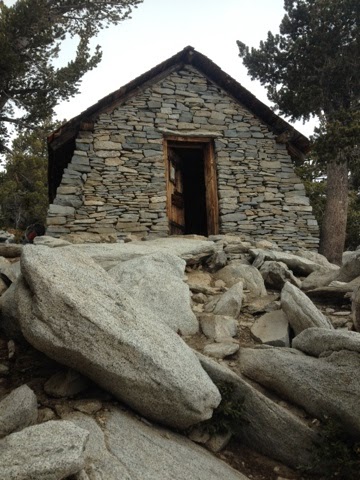
Hut

From the peak we descended a couple thousand feet before finally re-joining the PCT. The weather at this point had closed in on us and some fellow hikers who had summited maybe only 15 minutes after us reported they had no views on the summit block. The trail then followed Fuller Ridge down to approximately 7700' where we camped for the night at a road crossing. The miles down to camp were not as spectacular as they could have been given the shroud of mist and clouds we were enveloped in, but it was awesome in its own right with the wind pushing wispy clouds right by us as the air whipped over the tops of the ridges we were following. It was eerily beautiful and reminded us of our home mountains in the northwest.


At camp it was cold and windy and Mike and I set up right behind a huge boulder in a wind break. Right after we got set up, Sparrow called us out of our tent to see a tiny sliver of the next set of huge mountains all backed by a pastel sunset. Low hanging clouds obscured the bottoms of the mountains and made them look like islands. It was too cold out to look for long but it definitely made us excited for what was coming up on the trail.
No comments:
Post a Comment