Saturday, June 18, 2016

So...that last post took a lot of work. Too much work, really, if I have any hopes of consistently sharing our hikes.

Instead, I've created a way of making a video from our pictures. Here's my first two attempts.

Middle Fork Snoqualmie River

Bare Mountain

More to come.


Monday, May 16, 2016

Hello Again/Granite Lakes

A lot has happened since the PCT. 

Without getting into everything, I will say that Mike and I have persevered through some rough times but are happy to report we are doing better now. Life can be so difficult sometimes, but in every trial I believe there is something to be learned. 

Here's to living in the moment and finding balance. 

We are both currently working on finding a way to mesh our trail lives with our real lives which means finding time to set aside each week for hiking and adventuring. For the past couple of months we have been going on a weekly hike and I'd like to share this week's hike here. My hope is to use this blog now to document these adventures and be able to share them with all of you.
---
Near the trailhead, just heading off down the trail.
So here's some pics from this week's hike - an approximately 12.5 mile hike (round trip) to Granite Lakes. We have seen these lakes from above numerous times when we have climbed to the top of Dirty Harry's Peak, but we have never before made the long hike to the lakes themselves.

The weather was cloudy and misty and a cool 45°F at the lakes. Due partly to the weather, and partly to the hike itself being long and lacking in views, we had most of the trail to ourselves and only saw a handful of people the whole day.


Mike on a bridge over a stream.


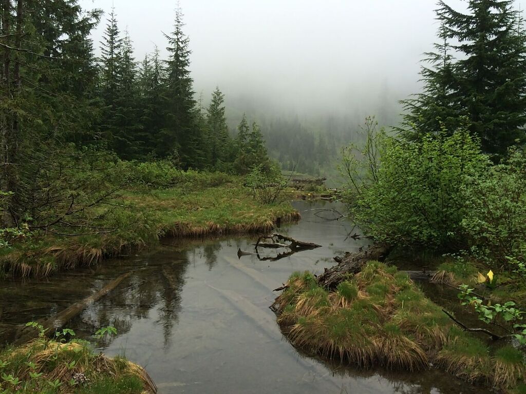
View leading downstream into the forest. 
View of stream from bridge.
Everything was very verdant and lush at the lower elevations. I swear it seems like on these cloudy and drizzly days, the forest looks even more vibrant and green than if it were sunny.


Springtime was in full force down here (at around 800'-1000') and we were delighted to find the first berries of the season!
GIANT and delicious Salmonberries. 
We didn't see much wildlife on this trip, save for an exceptional amount of banana slugs and a few snails. I can't even recall seeing any birds.

Big banana slug.


Snail


Look at these guys. Aren't they cute?


We had to tread carefully on the trail and watch our feet because the trail was littered with slugs. I hate stepping on them. :(

Laura making her way through a tangle of downed trees. Can you see the trail? Neither could we. 
Further on, we had to watch our feet...and our legs and heads, etc because we hit a section of the trail that was just destroyed by countless blowdowns. This section of trail had the most blowdowns (and worst blowdowns) I've ever seen in my hiking career.

Mike as seen through a tunnel of blowdowns. 


There were so many trees down that, at times, the trail became a tunnel we had to crawl through. Lots of trees had to be climbed over, or climbed under - sometimes we had to walk along downed trees, balancing like tightrope walkers, making sure not to slip on the slick wood. It certainly made for a great whole-body workout and was slow going and very tiring, but also very challenging and fun!


View obscured by clouds.


Trail sign at intersection framed by flora.


At some point we got a glimpse of the only views to be had on such an overcast day. As you can see, the lack of view was made up for by the dramatic and moody looking clouds drifting over and shrouding the nearby peaks. Sunny days are nice and all but days like these are what made us fall in love with the PNW. The weather just makes it feel otherworldly.


Hitchhiking slug.


Soon we made it to the trail intersection which meant we had only a mile or so to go to the lake. At this point I took off my backpack for a moment and got a startle when I discovered a slug had hitched a ride on my pack.

View of lake from its outlet. A single bright yellow skunk cabbage can be seen on the right. 
Getting to the lake was a little more difficult than expected due to the pathways being very overgrown. A couple of times we thought we had lost our trail, but a bit of bushwhacking did the job and we finally made it to our destination. It didn't seem like this lake is visited all that often and we enjoyed the fact that the perimeter of the lake wasn't marred by many human-made pathways and camp spots. It was just us, the drizzle in the chilly air, and silence. 

Mossy banks on the edge of the lake.


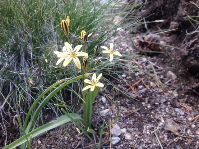
Around the lake we found a lot of different kinds of plants including beautiful purple heather (which is barely visible in the pic to the right), the very first blooms opening on some stalks of beargrass, flowers turning to fruit on the blueberry (or are they huckleberry?) bushes, and various other grasses and bushes.   


Me cheesing for a selfie at the lake. 


We stayed for maybe a half an hour but we soon became quite chilled even after putting on all the layers we had brought. Having to bushwhack so much to get to the lake meant that we had been dumped on by countless trees and shrubs that were heavy with collected rain. We were already pretty wet by the time we made it to the lake and we only became wetter as we hung out and took photos.   

Lake panorama complete with Mike and umbrella.
Moisture-laden foliage.
On our way back, we became doubly drenched since all the plants we had knocked free of rain had become wet again while we hung out at the lake. See proof above. 
Mike with umbrella on trail.
A handful of very ripe salmonberries. 
On our way out we filled up on more salmonberries which have a very delicate taste that is both tart and sweet at the same time. Mmm.

Overall, the hike was very enjoyable despite being lengthy, arduous, lacking in "views", littered with blowdowns, and overgrown at times. The weather was cloudy and cold but I think we made the best of what could be described as a dreary day. It was certainly a good hike for a day when climbing to a peak for views would have been pointless. The approx. 2000' of elevation gained over the ~6 miles was gained gradually and made it easy for us to keep a fast pace.  

Lastly, if you noticed, our destination was called Granite Lakes but we only actually visited one. I assure you, the other one was there, and we could have gone to it...but it would have required more rain-soaked bushwhacking to get to and so we declined. Guess it means we'll have to revisit this hike again some other time.  

---

Stats (one way):

Trailhead to Granite Lakes 

Miles: 6.2
Starting Altitude: 787'
Finishing Altitude: 3,091'
Step count: 12,690

Tuesday, September 1, 2015

Wrap-up

This has been an interesting year to attempt a thru-hike on the PCT for sure, and it's certainly been nothing like we imagined. In the beginning, we anticipated snow. On the contrary, with such extremely low snowpack in the Sierra Nevada this year, many Northbound hikers (ourselves included) were able to traverse these, the tallest mountains on the west coast, earlier than hikers historically could. Usually the feat would involve mountaineering equipment and the possibility of some formidable conditions. For us, it was practically a cake walk with little snow to speak of and nowhere to be found were the challenging stream and creek crossings we had heard so much about in past years. Although we did face a series of May storms, there were really very few snow obstacles that we faced on this trip. Instead, our hike was framed by issues of drought and then of fire and, to our surprise, almost all of the fire activity we encountered was at the end of the trail in our home state of Washington. 

If you'll remember, around the halfway point of our trip, we realized we needed to pick up our pace if we were to finish by the time we intended. From there on out, we set a moderately challenging goal of about 30 miles a day which we managed to consistently meet. Our days were long and grueling, but it was also very satisfying to be moving ever closer to the completion of our achievement.

We took a well-deserved near-0 day in Bend, OR (just before the 2000 mile mark) and while there we talked on the phone to our buddy who was behind us near the OR/CA border. We were told about smoky conditions and trail closures that were occurring, including a section through Crater Lake NP that we had just completed a week earlier. We were glad to be moving quickly, ahead of the growing fires in CA and OR and now we had WA in our sights. 

We crossed the Bridge of the Gods and left Oregon behind on Monday 8/10 heading towards Mt. Adams, the second tallest mountain in WA. Within a day we had climbed up again onto the ridge lines of the southern WA Cascades and the smoke from a fire that was burning on the south side of Mt. Adams began to obscure our views. By the time we climbed onto the neighboring mountains, we couldn't even see Adams. Half of the mountain and the wilderness which carries its name (including the summit) was closed with no plans to reopen until next year. The closure boundary followed the PCT and that could change to include the trail at anytime. Thankfully a storm front came through and although hiking all day in pouring rain isn't our favorite, it was definitely better than hiking through smoke. The weather broke as we hiked through Goat Rocks finally giving us some dramatic views  of the volcanos. Two days later the smoke was back. 

This became the pattern as we trekked through WA. As we moved further north we neared more fires and the closures continued.

As you probably know, WA is currently dealing with the largest wildfires in state history with the biggest ones burning in the north. When we arrived at Snoqualmie Pass, 250 miles from the Canadian border, we learned that in addition to a trail closure north of us near the town of Stehekin, the official PCT detour around the whole mess had also now closed because of a new fire in the North Cascades. Things were evolving so quickly the only thing we could do was continue north to Stevens Pass (70 miles ahead) and hope to hear better news when we arrived. Unfortunately, that wasn't really the case. Some hikers had pieced together a work-around the fire closure and now that was closed too due to yet another fire. We were surprised to hear of hikers calling it quits there due to all the uncertainty, confusion, and misinformation about what was actually going on.

The only option for us to reach the border now was to get a ride to the town of Chelan and take a ferry across Lake Chelan to Stehekin and reconnect with the trail there. The downside of this was that there were fires burning along the shores of the lake and we would be hiking between a few of the major fires in the area. 

Determined to not be shut out this year, we took the boat to Stehekin on Wednesday 8/26. The weather was calling for rain in a few days and we knew if we could make it until then we'd get our break. Upon arrival in Stehekin we were immediately met by NPS rangers and a member of a special firefighting team from Alaska who briefed us, answered our questions, and gave us the go ahead to finish our hike.

That day and the next were pretty smoky as we hiked to the west of the massive Okanogan complex fires. Arriving at Rainy Pass it was eerie to see a road and trailhead that would have normally been busy with summer vacationers completely empty because the highway was still closed due to fire. Finally early Friday morning we awoke to the storm that we had been counting on to bring us some relief. We've never been so excited to be hiking in the rain as we were that morning.

Reinvigorated, we hustled to Harts Pass, the last road crossing before the Canadian border and we were gifted with momentary breaks of blue sky and dramatic rolling clouds. 

The rain resumed and off again we went heading north for the last time. 

We reached the monument on Saturday August 29th at around 3:30ish and stood in the rain for at least 2 hours in total excitement and disbelief that we had made it. That day we saw elk, a bear, and tons of grouse but not a single person. It was a perfectly surreal way for us to end our amazing journey.

It was a quick 4 miles into Manning Provincial Park, BC to the PCT camp where we set up for the night. Rain and temps in the mid-30's helped us get out of camp quickly the next morning and before we knew it we were leaving the Manning Lodge on a bus to Vancouver. On the way back we learned that the previous days' storms had actually been worse than we had realized. All across Washington and British Columbia the storms gusted up to 65 mph, knocked down countless trees, took out power lines, and was even responsible for a few deaths. We watched out the window of the bus and saw signs of damage all across BC, and then into WA as we rode. We were standing in downtown Seattle by 10:15pm Sunday night still trying to process what exactly had just happened.

It was an incredible experience and everyday we felt fortunate to be on the trail. We are so thankful for all of our wonderful family and friends who have followed along with us on our hike and supported us even when things became a little crazy at the end. You guys are really the best. In the next few days we'll sort through all of our pictures and continue to share more. Thanks again and keep checking up to see more of our trip and what kind of adventure we might be getting into next!


Friday, July 10, 2015

Chester to Burney

July 10
Mile 1408
When we posted the last entry we were just leaving the town of Chester, CA. We managed to get in and out in under 4 hours which was an impressively short town stop. We heard in town that there were thunder showers forecasted for the evening and, unfortunately, the forecast was accurate. We had planned on doing about 20 miles out of Chester to catch our hiking buddy, but we only managed about 12 before the rain started with lightening and thunder following shortly after. We set up our tent and were asleep by 7pm due to the weather. We started early the next day at 4am to make up the mileage we lost to the storm and ended up doing our biggest mile day yet - 35 miles! It stormed that day too, for about 7 hours, with incredible lightning and heavy torrential rain for most of that time. We followed our 35 mile day with a 32 mile day yesterday, again catching thunderstorms in the afternoon. The storms just won't quit. I'm sitting in a McDonalds here in Burney writing this and yet again the clouds are building and turning dark and ominous. It looks like we might be in for round four today. :/
Yesterday we finished a portion of the trail that went through Lassen National Park, an area with incredible volcanic features including a boiling acidic lake and lava tubes, one of which we found unmarked and unnoticed right by the trail.
Mike looking into the lava tube.
The boiling springs lake, complete with bubbling mud pots around the perimeter.
Nice view on our early morning hike.
Scary clouds halfway through our 35 mile day.
More weather.
An informational outlook near Mt Lassen where we learned that we had been seeing Mt Lassen and not Shasta. Woops.
Taking a break from the storms at a water cache during a 30 mile waterless stretch of trail. In the pic it kinda looks like a hobo camp, but to us it was a magical oasis. It was novel to have some chairs to sit in. It's the little things!
A rainbow after the storm. It almost made the rain worth it... Almost.
I'm now at the grocery store finishing this entry up. We're trying to do another quick turn around here so we can fit in another 20-25 miles today. We'll take a rest in a few days when we get into the town of Mount Shasta. Wish us luck with the weather and the miles!


Tuesday, July 7, 2015

Halfway!

Hello folks - long time no blog! 
I'm happy to report that Mike and I are alive and well and as of yesterday evening we have completed half the PCT! 
Here we are at the post that marks the PCT midpoint. 
Since we left you a lot has happened! Some highlights:
•We did a 20 mile detour to finish the John Muir Trail which the PCT follows for 200 miles. It was awesome to complete a (world renowned) long trail in the middle of a long trail!
•After finishing the JMT we found ourselves in Yosemite valley and we took the opportunity to attempt a climb of Half Dome. Neither of us actually made it, but our buddy Sparrow somehow mustered the courage to tackle it. Hats off to him!
•We encountered our first wildfire! The flames were only a few short miles from us as we skirted around it. The trail was actually closed by rangers just after we passed through and all hikers behind us have had to miss 60 miles of trail due to it. Great timing on our part!
•We saw a bear! Just a few days ago we "bumped into" our first California bear who was grazing on a slope just off trail. The bear was cinnamon in color, almost golden, and was HUGE. No pics because we didn't want to get eaten. As for other wildlife, we have seen tons including numerous coyotes, jackrabbits, snowshoe hare, weasel, marmots, pikas, lizards, fish, crawdads, bats, rattlesnakes, etc.
•We have officially finished the Sierras! We've made it to the start of the Cascades and we are getting closer and closer to beautiful Mt Shasta which is looming in the distance. It feels nice to be near volcanoes again. We're definitely getting closer to home!
Thanks to everyone who has been following along with us, and we hope to be able to continue to share (sometimes shorter) updates when we can. Also, we're trying to pick up the pace now by doing close to 30 miles a day which doesn't always give us a lot of time to blog, so please bear with us. More to come- and as always- thanks for all of the encouragement and we love you guys! 

Thursday, June 11, 2015

Independence to Mammoth

Mile 788 - Mile 905
It was great to get back to the trail after our stop in Independence. We enjoyed our time in town but the Sierras have been so spectacular that we didn't mind leaving one bit. 
We've been seeing a lot of animals in the Sierra. Interestingly, they don't seem to be very afraid of people and are actually pretty curious.
So. Many. Marmots. These guys are super cute and live in all the rocky outcroppings so we see them all the time.
Deer grazing in the evening. The deer here completely ignore us and don't run away.
This chipmunk found us at a campsite and he was quite bold in trying to get our food.
A grouse just chilling on a rock. 
Bonus pic of a marmot, this time in front of an alpine lake.
Anyway, back to the hiking, here's a view into the High Sierra as we climbed up and over Kersarge Pass and rejoined the PCT/JMT.
Our next big pass was Glen Pass which was still snow covered and very steep. 
Obligatory picture of our 800 mile marker. Only 1850 left until Canada!
Climbing up a snowfield towards Pinchot Pass in the early evening. We could tell by the clouds that we would probably be having some weather moving in for the next couple of days.
Quick picture of our friend Croom before breaking camp and finishing the climb over Pinchot the next morning. It was a very cold night here at this spot.
Looking down from the pass at the lake basin as the clouds began to return.
Mike and Sparrow hustling down the valley as the snow started at the higher elevations.
Walking through intermittent snow showers and white-outs as we leave the valley and head back up to cross Mather Pass.
The guys making the long climb up to Mather as the weather breaks for a couple of minutes.
On top of Mather Pass relaxing and checking our maps. This was the second pass we climbed that day, and we were happy to have been able to complete it while the weather was cooperating.
On the descent the snow started again which made for dramatic views of the landscape.
A look back towards the pass as we descended deep into a valley. Here the weather started to get better.
Sparrow taking a moment to appreciate yet another amazing waterfall. We camped shortly after this once we hit treeline and found some protection in case the weather moved back in at night.
Gorgeous meadow the next morning as we head towards Muir Pass.
Lots of wildflowers beginning to pop up in the valleys.
Surrounded by granite giants as we make our way to Muir Pass.
Another beautiful waterfall on our ascent. Also, we thought the peaks in the middle-right of this photo kinda resembled an eagle with outstretched wings. We had to take cover shortly after this photo due to thunder, lightning, and snow. It only lasted about an hour, but we felt glad to see it pass as we were clearing treeline in a very exposed section. 
Alpine lake with the reflection of the surrounding mountain. 
The views became very dramatic as we approached Muir Pass. It continued to snow lightly on and off for the next hour or so.
Crossing snowfields on our way to the pass.
Almost to the pass as sunset is quickly approaching.
Finally at the pass we see the famous Muir Pass hut.
We descended from the pass as the sun set and enjoyed an amazing landscape that felt like Greenland.
 
Sunlight fading over a lake below the pass. An hour later clouds rolled back in and the snow began to fall once again as we set up camp for the night. Thankfully when we woke the next morning there was less than an inch of accumulation and it melted quickly.
Alpine lake and clear skies again.
Beautiful river where we took a lunch break.
Sparrow,Mike, and Croom fording another river.
Climbing another ridge on the way to Reds Meadows.
Reaching another milestone, we finally feel like we're making our way through California. This state is a beast! 
It was only a few miles more to Reds Meadows (a USFS campground on a road close to Mammoth Lakes, CA) where we hitched to town for our resupply. Our hitch was super interesting since the girl who picked us up actually was a wildlife biologist studying weasels in the area. We asked a ton of questions and learned a lot about the local wildlife.
While in town our friend Julien bought electric hair clippers so Laura treated Mike and Sparrow to a trim. So fancy!
Mammoth was a great town stop, we accomplished a lot, and we are excited to finish the Sierra and see what else is in store on the trail. 
Until later!